
by Stefanos Folias
Last week my good friend Nat Smale and I spent 5 days on the Escalante river of Utah to descend some of the narrow, water–filled slot canyons that are tributaries of the Escalante river. We had planned this trip since mid–May, as autumn is a nice time along the Escalante, with cooler temps and infrequent flash floods—compared with July through September—and is at a time when we both have a regular holiday from work. Anticipation for the trip was building as the days approached closer and closer, considering Escalante is possibly our favorite area of Southern Utah and the Colorado Plateau. It was not obvious beforehand that a 50–year storm would inundate Southern Utah with raging torrents. And while walking these Southern Utah washes for years offers signs and hints of how and where water is capable of going, one is left unprepared for the experience of witnessing it. Simultaneously filled with horror and excitement—it was simply an unreal experience.
The Escalante cuts through the structurally weakened spine of an uplift of bowing layers of colorful sedimentary rock, with spectacular sidecanyons (tributary systems) adorning its entire length, as it makes its way from the highlands of the Aquarius Plateau down to the depths of a section of the Colorado River known as Glen Canyon (Lake Powell). The sidecanyons meander sinuously as they cut their way through the erosive rock, some wide and deep, some impossibly narrow and beautifully sculpted. Literally, narrow slits in the rock, slot canyons act as constrictive drains for the rain water that falls on the large expanses of mostly barren rock and soil comprising much of this area. Even a short, strong dose of 20–minute rainfall is capable of causing a deadly flashflood, should one be caught within one of these slot canyons, many of which have no routes of escape.
The forecast a week before the trip called for relatively good chances for rain 20–40% as a system would be moving in from the southwest. One of the problems with planning a trip like this is the risk of it spoiled by a sufficiently good chance of rain. We kept in mind the possibility of changing the dates. Since I was flying in from Boston, Mass. (where I had moved from my home in Salt Lake just a year before), this created further complications with decision and timing. We decided to watch the weather and make a decision at the last minute before my flight. The weather seemed to improve a little, as the National Weather Service began to suggest that the storm would be moving in a more northerly direction, with the brunt of it hitting northern Utah. And although there was still some chance of rain, we felt that most of the days would probably work out—in Southern Utah there is always the chance that it’ll eventually turn out to be mostly clear and sunny. However, it was noted that some of the models did, in fact, predict that the storms could hit the southern part of the state.
We decided to keep the plans and I arrived in Salt Lake on Tuesday night (6 hours later than expected). The weather forecast remained consistent from Monday through early Wednesday morning, calling for partly cloudy through the weekend with a 30% chance on Wednesday (Oct. 4), a 20% chance on Thursday, a 30% chance on Friday, and a 20% on both Saturday and Sunday. We planned to descend four slot canyons near the Egypt bench along the middle section of the Escalante River, and Thursday–Sunday would have to boast good weather to feel comfortable entering these canyons.
This would be the last point we had any predictive information about the weather.
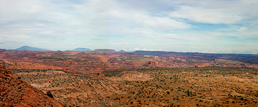
From the Egypt Bench looking east towards the Escalante.
From the Egypt bench we arrived in the late afternoon on Wednesday to find quite nice, partly cloudy weather, during what carried a 30% chance of rain. We hauled our packs full of food and gear down a pair of large sand and rock shelves to the Escalante River. The slender river, at the mouth of Neon Canyon, is entrenched in the sandy, cottonwood–strewn flood plain of the Escalante River canyon, and, while the water was only calf to knee deep, the slender depression itself was well over our heads. We made our way into familiar Neon Canyon and settled our camp high on a sandstone bench just a short ways upcanyon.
— October 5, 2006 —
Day 1: Choprock Approach
& Upper Neon Scouting
We woke up the following morning to a light sprinkling of rain, which lasted less than a couple of minutes and added up to no amount of water. Clouds were moving somewhat quickly overhead from the southwest and kept the morning dim, with a few breaks of sunlight. The approach to the neighboring canyon to the north was a moderate distance away, so we figured we would watch the weather develop and make a decision at the drop–in point of the slot canyon.

Lower Neon slot from the rim.
The east/south fork of Choprock Canyon is a long slot canyon, with no escapes for much of its length, and would take the better part of a day to descend. It would be hazardous if there was a good chance of rain at any time inside. Nat and I had a close call a few years earlier on a day with ZERO chance of rain. The day began overcast with dense clouds, turned to bright sunny skies, and, ultimately, developed into a charging storm that delivered a 20–minute blast of rain which, fortuitously, tore though the canyon as a raging flash flood just 20 minutes after we had finished the slot canyon’s 155–foot exit rappel (from a natural anchor we took 45 minutes to build). I tried to be optimistic for much of the hike up the Choprock Bench, saying, “The storm looks like it’s moving northerly, condensing upon the highlands of the Kaiparowitz and Aquarius plateaus.” But inside I agreed with Nat, that it really wasn’t looking good. The bench served as an excellent vantage point for the weather that was amassing to the west. While the clouds above us were thin and hardly filled with water, there was a frighteningly dark grey mass of thick clouds not far to the west.

Dark clouds of the storm to the west.

Upper Choprock Canyon from Choprock bench.
Upon arrival to the drop–in point of the slot, we decided that we should NOT enter and, instead, spend the rest of the day scouting out an entrance into upper Neon Canyon, above the highest slot. We sat and had a snack, maveled in the expansive views over the forks of upper Choprock Canyon, and watched the storm to the west. This, unfortunately, meant we would only have time for three of the canyons, but it’s better to be safe. After lunch we made our way from the bench towards the upper forks of Neon Canyon. During our approach, we watched in amazement as the moisture–laden clouds that earlier had been moving northerly had now shifted and were moving rapidly towards us. We watched as the watery shine of wetted rock approached closer and closer, ultimately encompassing the whole of the Escalante area.

Silver shine, rain in upper Neon Canyon.
Rain fell moderately hard as wind and lightning flashed across the sky. We took shelter under some junipers and let the rain subside. Later during our exploration of routes into upper Neon, the rain started again, this time quite a bit stronger than before. We took shelter under a short overhang and decided to eat lunch. The sky beamed silvery white and the wetted rock mirrored in reply. Apparently, we had made a good decision not to enter the canyon as the small sidecanyon below developed a decent flow.

Rainwater filling pools, upper Neon Canyon.
After finding a rappel–less route into upper Neon, we rim–walked the canyon back to camp. At moments of our return route along the rim, we could hear lower Neon’s slot resounding with the crash of water—a strong flow had developed, from the draining of the upper reaches of the canyon. Upon returning to camp, I dropped my pack and quickly jaunted up to the Golden Cathedral in lower Neon Canyon to marvel at the waterfall through the double natural bridge. It was spectacular and dynamic; the rushing volume of water pounded upon the pool and resonated loudly within the alcove. It is along this waterfall that one finally rappels when descending Neon Canyon. Rain began to sprinkle again and I made my way back to camp.

Falls in the Golden Cathedral after rainstorm.
After dinner it got dark and continued to rain lightly/moderately, and we decided to see what the weather would be like in the morning. If it rained hard today and was only 20%, what did 30% have in store for us, I wondered. I wasn’t quite ready to sleep, so I spent sometime crouching under a very short alcove at the base of a terraced wall behind our camp. Slightly uncomfortable, it was almost completely away from the rain. It was in this alcove that I would elude the most intense rains of the following day. Finally, I decided to crawl into my sleeping bag, snugly shielded inside a bivy sack and a rain jacket to cover my face. Rain continued thoughout the night and I felt the incessant pitter–patter of rain (more appropriately ratta–tat–tat) upon my quite intimate shelter. It possibly was due to the superbright and unusually large harvest moon that I couldn’t sleep, but I distinctly remember—for much of the late night and early morning—the resounding sound of a rushing torrent of water just below our sandstone bench, filling lower Neon Canyon ...
© 2006 Stefanos Folias