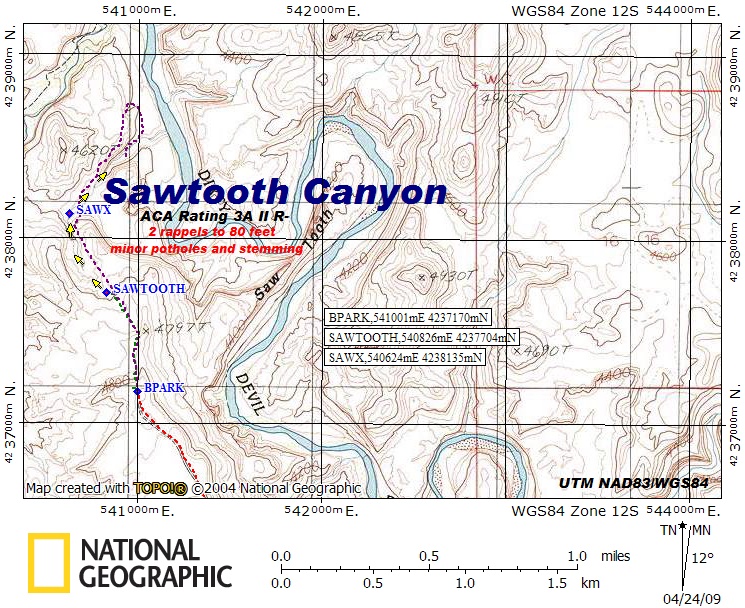

Sawtooth Canyon
Hanksville Area\Dirty Devil River, Utah
ACA Rating: 3A II R-
2 rappels to 80’
minor potholes and stemming
Hanksville Area\Dirty Devil River, Utah
ACA Rating: 3A II R-
2 rappels to 80’
minor potholes and stemming
GENERAL DESCRIPTION:
A 1½ to 3 hour canyon with some minor potholes,
a short stemming section, and a couple of rappels.
GEAR:
Standard Canyoneering Gear.
Rope, webbing, and quick links for 2 rappels to 80 feet.
DRIVE:
Drive south on Hwy 95 from Hanksville and turn east at mile post 10.1 onto the BLM signed road to Angel Trail. You will bypass several lesser dirt roads on your way. Stay on the main road unless instructed to turn. Drive approximately 2.4 miles and turn right (southeast) at a Y in the road [ATTURN, UTM NAD83\WGS84 534094mE 4232786mN]. Continue 3.4 miles and turn left (northeast) at BTURN, UTM 538061mE 4230236mN. This section of dirt road will have some sandy and bumpy spots and may require a 4WD and high clearance vehicle. Drive another 4.3 miles and turn left (north) on a faint track at BTURN2, UTM 541540mE 4235999mN. Drive 0.8 miles and park at BPARK, UTM 541001mE 4237170mN on the rim above the Sawtooth on the Dirty Devil River. Driving time from Hwy 95 is about 40 to 50 minutes.
HIKE:
Hike down off the rim to the north and make your way to the head of the canyon at SAWTOOTH, UTM 540826mE 4237704mN as shown on the map.
EXIT:
After completing the final rappels, exit to the left (north) up out of the drainage on loose sand and ledges. Follow the route on the map to make your way along the sandstone rim of the canyon on the right side while looking up canyon (LUC). Cross the canyon above the rappels in a wide open area marked SAWX [UTM 540624mE 4238135mN] on the map. Continue to hike the Navajo Sandstone along the left side of the canyon (LUC) until you can follow your route back to your vehicle.
COMMENTS:
Shorter Option: It is possible to exit the canyon at the area marked SAWX on the map. This option includes no rappels and takes approximately 1½ to 2 hours.
A 1½ to 3 hour canyon with some minor potholes,
a short stemming section, and a couple of rappels.
GEAR:
Standard Canyoneering Gear.
Rope, webbing, and quick links for 2 rappels to 80 feet.
DRIVE:
Drive south on Hwy 95 from Hanksville and turn east at mile post 10.1 onto the BLM signed road to Angel Trail. You will bypass several lesser dirt roads on your way. Stay on the main road unless instructed to turn. Drive approximately 2.4 miles and turn right (southeast) at a Y in the road [ATTURN, UTM NAD83\WGS84 534094mE 4232786mN]. Continue 3.4 miles and turn left (northeast) at BTURN, UTM 538061mE 4230236mN. This section of dirt road will have some sandy and bumpy spots and may require a 4WD and high clearance vehicle. Drive another 4.3 miles and turn left (north) on a faint track at BTURN2, UTM 541540mE 4235999mN. Drive 0.8 miles and park at BPARK, UTM 541001mE 4237170mN on the rim above the Sawtooth on the Dirty Devil River. Driving time from Hwy 95 is about 40 to 50 minutes.
HIKE:
Hike down off the rim to the north and make your way to the head of the canyon at SAWTOOTH, UTM 540826mE 4237704mN as shown on the map.
EXIT:
After completing the final rappels, exit to the left (north) up out of the drainage on loose sand and ledges. Follow the route on the map to make your way along the sandstone rim of the canyon on the right side while looking up canyon (LUC). Cross the canyon above the rappels in a wide open area marked SAWX [UTM 540624mE 4238135mN] on the map. Continue to hike the Navajo Sandstone along the left side of the canyon (LUC) until you can follow your route back to your vehicle.
COMMENTS:
Quality Rating: 
Shorter Option: It is possible to exit the canyon at the area marked SAWX on the map. This option includes no rappels and takes approximately 1½ to 2 hours.