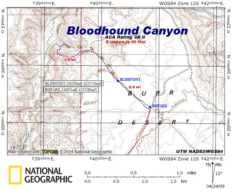

Bloodhound Canyon
Hanksville Area\Dirty Devil River, Utah
ACA Rating: 3A II
5 rappels to 30’
Hanksville Area\Dirty Devil River, Utah
ACA Rating: 3A II
5 rappels to 30’
GENERAL DESCRIPTION:
A 2½ to 3½ hour canyon with some minor potholes
and 5 rappels to 30 feet.
GEAR:
Standard Canyoneering Gear.
Rope, webbing, and quick links for 5 rappels to 30 feet.
DRIVE:
Drive south on Hwy 95 from Hanksville and turn east at mile post 10.1 onto the BLM signed road to Angel Trail. You will bypass several lesser dirt roads on your way. Stay on the main road unless instructed to turn. Drive approximately 2.4 miles and turn right (southeast) at a Y in the road [ATTURN, UTM NAD83\WGS84 534094mE 4232786mN]. Continue 3.4 miles and turn left (northeast) at BTURN, UTM 538061mE 4230236mN. Drive an additional 3.8 miles and park at BHPARK, UTM 540851mE 4235280mN. This section of dirt road will have some sandy and bumpy spots and may require a 4WD and high clearance vehicle. Driving time from Hwy 95 is about 30 to 40 minutes.
HIKE:
From the parking spot, hike northwest as shown on the map, following the drainage to where the slot begins to form at BLDHNDST, UTM 540290mE 4235743mNx.
EXIT:
After completing the canyon, exit to the left (west) at the first opportunity by way of an obvious weakness formed by a very small bowl–shaped gully. After topping out on the first level spot, make your way right (west) up a second sandstone slope to the top of the next level area. At that point is is possible to hike along the rim above the canyon to return up the canyon drainage and back to your vehicle.
COMMENTS:
This canyon is not very technical and allows many places to escape. It is an enjoyable hike in a shallow pothole drainage with a few rappels. If you continue beyond the exit described, it is likely that you will find cool, clear water flowing in the main Beaver Canyon drainage.
A 2½ to 3½ hour canyon with some minor potholes
and 5 rappels to 30 feet.
GEAR:
Standard Canyoneering Gear.
Rope, webbing, and quick links for 5 rappels to 30 feet.
DRIVE:
Drive south on Hwy 95 from Hanksville and turn east at mile post 10.1 onto the BLM signed road to Angel Trail. You will bypass several lesser dirt roads on your way. Stay on the main road unless instructed to turn. Drive approximately 2.4 miles and turn right (southeast) at a Y in the road [ATTURN, UTM NAD83\WGS84 534094mE 4232786mN]. Continue 3.4 miles and turn left (northeast) at BTURN, UTM 538061mE 4230236mN. Drive an additional 3.8 miles and park at BHPARK, UTM 540851mE 4235280mN. This section of dirt road will have some sandy and bumpy spots and may require a 4WD and high clearance vehicle. Driving time from Hwy 95 is about 30 to 40 minutes.
HIKE:
From the parking spot, hike northwest as shown on the map, following the drainage to where the slot begins to form at BLDHNDST, UTM 540290mE 4235743mNx.
EXIT:
After completing the canyon, exit to the left (west) at the first opportunity by way of an obvious weakness formed by a very small bowl–shaped gully. After topping out on the first level spot, make your way right (west) up a second sandstone slope to the top of the next level area. At that point is is possible to hike along the rim above the canyon to return up the canyon drainage and back to your vehicle.
COMMENTS:
Quality Rating: 
This canyon is not very technical and allows many places to escape. It is an enjoyable hike in a shallow pothole drainage with a few rappels. If you continue beyond the exit described, it is likely that you will find cool, clear water flowing in the main Beaver Canyon drainage.