
Angel Slot
Hanksville Area\Dirty Devil River, Utah
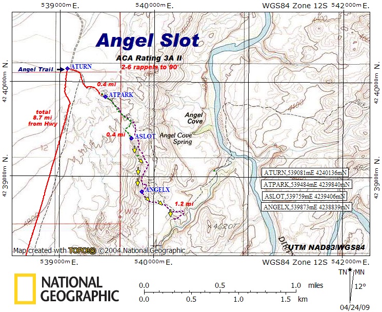
ACA Rating: 3A II
2–6 rappels to 90’
Hanksville Area\Dirty Devil River, Utah
ACA Rating: 3A II
2–6 rappels to 90’
GENERAL DESCRIPTION:
A 3 to 4 hour canyon with a few rappels, downclimbs, and fun narrows.
GEAR:
Standard canyoneering gear.
Rope, webbing, and quick links for 2–6 rappels to 90 feet.
DRIVE:
Drive south on Hwy 95 from Hanksville and turn east at mile post 10.1 onto the BLM signed road to Angel Trail. You will bypass several lesser dirt roads on your way to Angel Trail. Stay on the main road unless instructed to turn. Drive approximately 2.4 miles and turn left (northeast) at a Y in the road [ATTURN, UTM NAD83\WGS84 534094mE 4232786mN]. Continue 5.8 miles and turn right (southeast) at ATURN, UTM 539081mE 4240136mN. Drive 0.4 miles to the parking spot at the top of the Angel Trail [ATPARK, UTM 539484mE 4239840mN]. Driving time, from Hwy 95 to the parking spot, is approximately 20 to 30 minutes. These dirt roads can be sandy and bumpy, but are generally passable to 2WD vehicles.
HIKE:
Hike down the Angel Trail about 0.3 miles to a level, sandy spot in the trail, then turn to your right (west) and make your way to the head of the slot at ASLOT, UTM 539748mE 4239406mN.
EXIT:
After completing the final rappel, hike up the sand bank to the east onto the earth bench above the Beaver Canyon watercourse. Continue east along the bench a hundred yards to where you can ascend a sandy talus slope to a cairned stock trail as shown on the map. Upon reaching the slickrock rim above Beaver Canyon, make your way back up the Angel Slot drainage to the exit on the east at ANGELX, UTM 539873mE 4238839mN. Climb out of the canyon and hike up the slickrock benches above the canyon to the rim where you can take the Angel Trail back to your starting point.
COMMENTS:
Shorter Option: For a 2 to 3 hour outing, exit the canyon on the east at your first opportunity in the vicinity of the waypoint on the map named ANGELX, (UTM 539873mE 4238839mN) and make your way to your vehicle as described in the EXIT information and shown on the map.
A 3 to 4 hour canyon with a few rappels, downclimbs, and fun narrows.
GEAR:
Standard canyoneering gear.
Rope, webbing, and quick links for 2–6 rappels to 90 feet.
DRIVE:
Drive south on Hwy 95 from Hanksville and turn east at mile post 10.1 onto the BLM signed road to Angel Trail. You will bypass several lesser dirt roads on your way to Angel Trail. Stay on the main road unless instructed to turn. Drive approximately 2.4 miles and turn left (northeast) at a Y in the road [ATTURN, UTM NAD83\WGS84 534094mE 4232786mN]. Continue 5.8 miles and turn right (southeast) at ATURN, UTM 539081mE 4240136mN. Drive 0.4 miles to the parking spot at the top of the Angel Trail [ATPARK, UTM 539484mE 4239840mN]. Driving time, from Hwy 95 to the parking spot, is approximately 20 to 30 minutes. These dirt roads can be sandy and bumpy, but are generally passable to 2WD vehicles.
HIKE:
Hike down the Angel Trail about 0.3 miles to a level, sandy spot in the trail, then turn to your right (west) and make your way to the head of the slot at ASLOT, UTM 539748mE 4239406mN.
EXIT:
After completing the final rappel, hike up the sand bank to the east onto the earth bench above the Beaver Canyon watercourse. Continue east along the bench a hundred yards to where you can ascend a sandy talus slope to a cairned stock trail as shown on the map. Upon reaching the slickrock rim above Beaver Canyon, make your way back up the Angel Slot drainage to the exit on the east at ANGELX, UTM 539873mE 4238839mN. Climb out of the canyon and hike up the slickrock benches above the canyon to the rim where you can take the Angel Trail back to your starting point.
COMMENTS:
Quality Rating: 
A fun little slot with a few rappels and downclimbs.
Shorter Option: For a 2 to 3 hour outing, exit the canyon on the east at your first opportunity in the vicinity of the waypoint on the map named ANGELX, (UTM 539873mE 4238839mN) and make your way to your vehicle as described in the EXIT information and shown on the map.