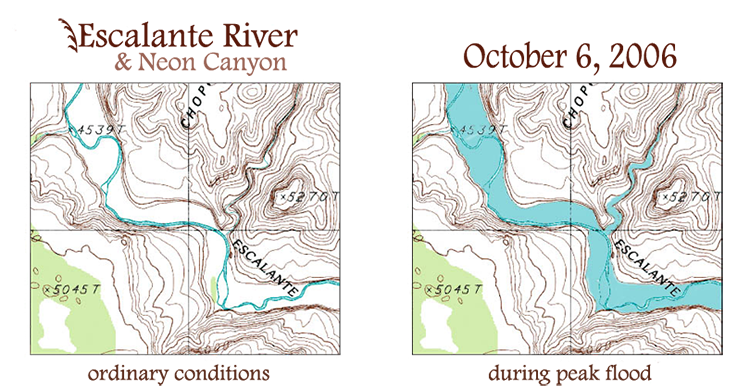
— October 6, 2006 —
Day 2: Escalante Deluge
Without getting up, it was simple to deduce that a significant amount of water was flowing through the canyon and there would be no canyoneering today! At one point in the early morning around 7am, there was a momentary surge in rainfall, which insisted for about 30 minutes then relaxed to a moderately strong rain for some time. During the tail end of the pulse of rain and some time thereafter, the terraced sandstone wall behind our camp was cascading with huge, muddy, rooster–tailing waterfalls and a torrent moving through the sandstone basin, down to the floor of Neon Canyon ... absolutely wild. I emerged from the bivy sack when it finally turned to a light rain, put on my raingear, and walked around our sandstone bench, in awe of the river raging through the watercourse below, spanning from wall–to–wall. It was an exhilarating scene to awake to. The Golden Cathedral must have been quite a vigorous waterfall! At this point I took a number of photos then sat and talked with Nat a little while getting my food for breakfast.
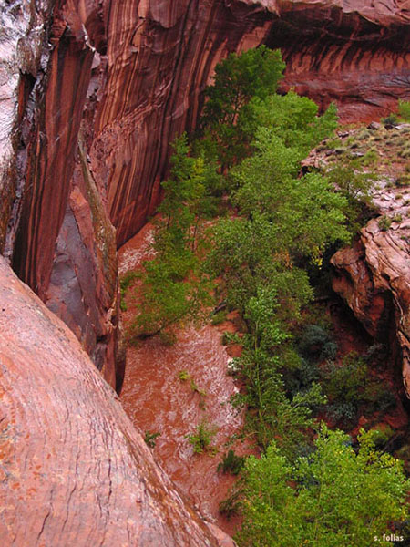
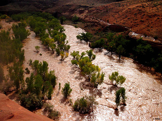
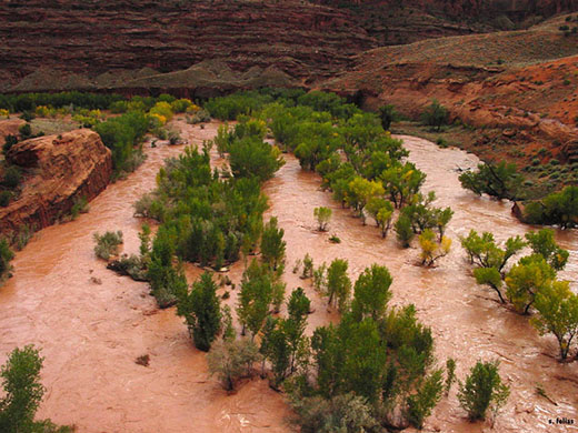
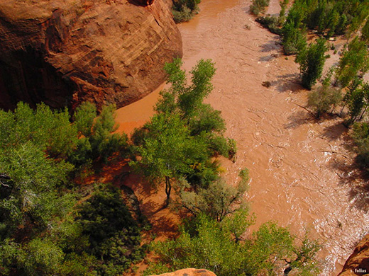
Flood in lower Neon canyon.
Dark clouds moved in briskly, and ultimately (around 9:30) it started to rain ... again. From the slowly but steadily increasing drops of rain, you got the sense that it was about to pour. Nat ducked into his tent, and I grabbed my food and a waterbottle and headed for my dwarfish overhang. Within moments, the rain developed into a second super–pulse lasting about 30 minutes; and again, descending the terraced wall, the frenetic, sandy waterfall enveloped the alcove opening—now before me—pooled into a torrent, and careened to join the Neon torrent below.
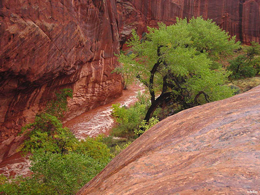
Flood in lower Neon canyon.
Eventually a moderately strong rain ensued and I carried my food and water uphill to the top of the terraced wall and into another small overhang with a nice view of the sandstone bench, where we were camped, and the bend in the canyon beyond. Water rushed steadily down the canyon and impressively spanned the widened bend, essentially from wall–to–wall. The sandbar sitting inside the U–shaped bend was completely submerged, as well as the limbless section of the trunk of a small cottonwood tree perched upon it. The water reached up to the leafy limbs of the cottonwood, indicating that the water was impressively deep. At this point it was relatively cold, the rain persisted, and I didn’t feel like doing much more than soaking in this rare experience. At some point the rain mostly stopped and dim, moisture–laden clouds continued to pass overhead from the southwest.
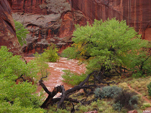
Flood in lower Neon canyon.
It was nice to walk around for awhile and at some point Nat joined me on my high–perched ledge above camp. As we sat and talked, the flow in Neon had reduced quite a bit, and the sandbar in the U–shaped bend had emerged some, including the island–like promontory where the submerged cottonwood perched. Strangely, as we continued to talk, the water, at the bend beyond camp, not only rose again to submerge the sandbar and trunk of the cottonwood entirely, but almost completely haulted its flow altogether. Something was damming the flow and holding a significant amount of water in what I fondly dubbed “Lake Neon.”
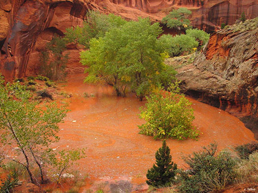
Lake Neon.
After examining this lake from other vantage points down below, we decided to climb up onto the narrow ridge that forms the northern west wall of the mouth of Neon Canyon, separating our camp and the Escalante river. As we reached the apex of the ridge, an untamed scene enveloped our eyes!
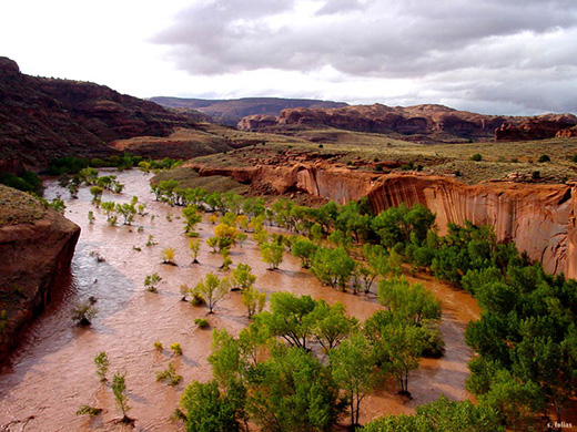
It took a moment for me to comprehend the enormity of it all—the entire Escalante flood plain at the base of the canyon was filled from wall–to–wall within the wingate (bottom) layer.
The raging water formed rapids over the sandbars, bushes and trees below, as well as whirlpools and wakes in its flow about the many cottonwood trees scattered around the flood plain. The canyon resounded with the crashing water of this impressive deluge. Occasionally large thickets of tree snags were carried afloat and often approached the wading cottonwoods. Some were capable of bending tall but slender cottonwoods, completely drowning them as they passed over. Others were caught momentarily, or permanently, on the up–flow side of the trunk—something you see sometimes, perched high on the trunks of trees while walking along the Escalante, or other canyons on the Colorado Plateau. We even heard cottonwoods crack under the drag force these clusters of tree branches/trunks thrust upon them, occasionally snapping and submitting to the downstream flow.
Looking up the Escalante towards Choprock canyon.
For awhile we stood speechless at the astounding sight, and it was—now—stunningly clear what precisely had dammed the flow in Neon canyon.
Though clouds continued to rush across the sky, pockets of sunlight shone through, enlightening the canyon and the swirling, twisting water below. For quite some time we sat and talked profoundly, with our gazes glued to the river from our lofty vantage point a couple hundred feet above. There was no way to cross the river even if we had wanted to. Who knows how deep it was at its deepest point—possibly 3, 4 or 5 times overhead? None of the underbrush (on the sandbars) and short trees were even visible, and it was clear the flow was a marked distance up the sandstone canyon walls. Nat suggested that this was quite possibly the most astonishing thing he’d ever seen outdoors ... I had to agree.
The entire Escalante canyon and its profusion of tributaries ALL were massively flooded ... and raging.
Looking south/southwest from Neon canyon.
Looking down the Escalante from Neon canyon.
Dam at the mouth of Neon canyon ... origin of Lake Neon.
As the sun was going down, with darker clouds rolling in, we
decided to return to camp. Nat prepared a beverage and I was in the
process of preparing mine, rushing to gather food and some of my clothing I
had scattered about to dry; more dark clouds were coming and I was worried
about more rain. Nat responded, “It’s
not as if any more rain is needed,” hilarious irony given what we had just experienced. Apparently it was needed! A light sprinkle intensified and the same scenario played itself out again. Nat ducked into the tent, and I scurried, with my beverage in hand, back to my dwarfish alcove. As rapidly as before, the
rain developed into another super–pulse lasting about 30 minutes, as I sipped
my drink and delighted in yet another muddy waterfall and torrent ensuing before me. The super–pulse relaxed some to a moderately strong rain and persisted for
another hour, after which the rain stopped.
I had no idea how much
time had passed, but Nat had been monitoring the length of the intense rains.
Neon was raging again and no longer a lake—how deep was the Escalante now?—and it was finally calm enough to
enjoy our dinner. We estimated from how much Nat’s cup was filled that about 5–6′′ of rain had fallen since the night before. The amount of water was astonishing. Fortunately this last super–pulse was the finalé of a
stupefying storm. I took comfort in sleeping in the tent, with deep hopes and
crossed fingers that the weather would clear for us to safely do some canyons
during the following days. Moderate rain fell during the early part of the
night, and it seemed that the storm was letting up some.
• The Warning We Missed •
Roughly at the time we parked our vehicle at the end of the Egypt road, Brian McInerney, hydrologist/flood forecaster at the National Weather Service, issued the following initial Flash Flood Watch when it became clear that a wide, dense finger of rainfall, as wide as the state, was sweeping upwards through Arizona and heading directly for Southern Utah ... very likely leading to immense flooding. Our timing would appear uncanny.
RECREATION AREA/LAKE POWELL ... HENRY MOUNTAINS ...
SOUTH CENTRAL UTAH AND UTAHS DIXIE AND ZION NATIONAL PARK.
* FROM THURSDAY MORNING THROUGH FRIDAY AFTERNOON.
* MOIST SOUTHWEST FLOW IS EXPECTED TO PRODUCE EXCESSIVELY
HEAVY RAINFALL IN THE WATCH AREA. RAINFALL WILL OCCUR OVER
MUCH OF THE WATCH AREA TONIGHT. HOWEVER ... THE HEAVIEST
RAINFALL IS EXPECTED TO BEGIN THURSDAY MORNING AND CONTINUE
THROUGH FRIDAY AFTERNOON. WIDESPREAD RAINFALL AMOUNTS OF
OVER 3 INCHES ARE ANTICIPATED BY FRIDAY EVENING.
* AS A RESULT OF THE HEAVY RAINFALL ... WIDESPREAD FLASH
FLOODING IS ANTICIPATED. FLASH FLOODING IS EXPECTED TO
OCCUR IN DRY WASHES ... SLOT CANYONS ... AND MAINSTEM
RIVERS IN THE WATCH AREA. A FLASH FLOOD WATCH MEANS
THAT CONDITIONS MAY DEVELOP THAT LEAD TO FLASH FLOODING.
FLASH FLOODING IS A VERY DANGEROUS SITUATION. YOU SHOULD
MONITOR LATER FORECASTS AND BE PREPARED TO TAKE ACTION
SHOULD FLASH FLOOD WARNINGS BE ISSUED.
$$
FOR MORE INFORMATION FROM NOAA/S NATIONAL WEATHER SERVICE
VISIT ... http://weather.gov/saltlakecity
MCINERNEY
In correspondance with Brian McInerney after the storm, I learned that, before issuing the Flash Flood Watch, he called the folks at the park and monuments in Utah to inform them of the magnitude of the approaching storm and ensuing flooding. This allowed the parks and monuments to affect access, shut down scenic drives, stop issuing permits, and inform travelers, hikers, etc. before the storm hit. However, he was concerned that they were not able to inform some of the folks who needed the information most.
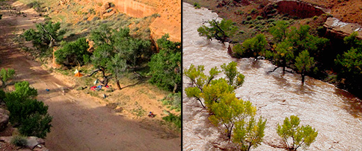
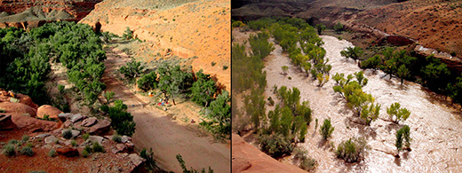
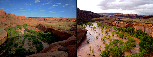
Comparisons: During & After
Photos by Randi Poer & Stefan Folias
I would like to acknowledge Randi Poer for being so incredibly kind, as she took a few photos from roughly the same vantage points of some of my shots during her recent (May 2007) trip to Neon and Choprock. I have cropped precisely and placed our photographs side–by–side for comparison of conditions after and during the flood.
Notice the bare tree limb almost touches the water.
Escalante flood plain at the mouth of Neon Canyon.
Escalante River, upcanyon towards Choprock Canyon.
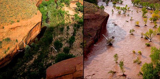
Flood close–up. Arrows compare similar elements.
Lake Powell Elevation Change
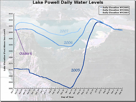
Lake Powell flood graph.
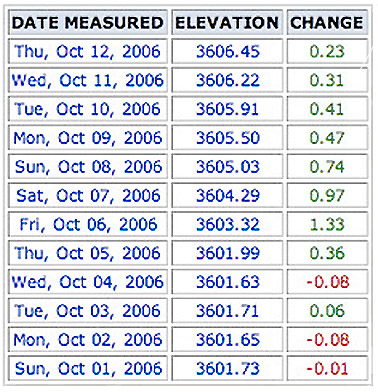
Lake powell storm data (click for full table).
Radar Animation on October 6
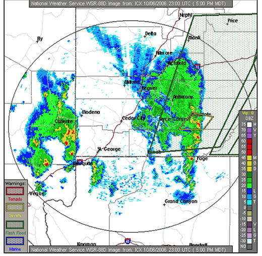
NWS radar during the storm (click for animation).
© 2006 Stefanos Folias